Expeditionary road trip along the Pamir Highway
Tour dates: June 3 - 16, 2026
For today, January 24, 2026, 4 places from 6 are available on this tour.
The Pamir Highway is the "roof of the world", the highest, most difficult route of the former USSR. Travel time on it cannot be calculated by hours or even days: at any moment it can be closed for 2-3 days due to rockfalls, avalanches and mudflows. Punctured tires and mufflers, boiling engines, cracks from stones on the windshield - this is all about the Pamir Highway. A well-prepared SUV, a set of tools and spare parts for all occasions, two or three spare tires and canisters of gasoline, driving skills and nerves of steel of the driver are important components of successfully overcoming this route.
At the same time, the Pamir Highway is one of the most picturesque and colorful roads in the world! Breathtaking views of the Afghan six-thousanders, waterfalls and hot springs, fantastically beautiful green valleys between snow-white mountains, Zoroastrian sanctuaries and the highest mountain monument to Lenin, ancient petroglyphs and fortresses of the Great Silk Road, the hospitality of local residents - all this is also the Pamir Highway!
This trip is unique in that you yourself are unlikely to dare to do it - you need a good SUV, the drive to the Pamirs is long and difficult, the highway itself is a challenge for both you and your car. For us, it is part of the Big Auto Expedition from Moscow to Sakhalin and we will travel along it regardless of the group composition and any other circumstances!
We invite only real travelers, explorers of the world, to share this journey with us, ready to sacrifice comfort for the opportunity to see, learn and feel something new, experience strong emotions, who value friendship and human relationships above all else and are ready to be part of a team, ready for unforeseen circumstances and, what's more, who get a real thrill from these circumstances and unplanned meetings, views and opportunities to learn something new...
We are going at the best time for traveling to the Pamirs, when there are the maximum number of sunny days in the mountains, little rain (and therefore rockfalls and mudflows) and even at night high in the mountains it is not as cold as at any other time of the year.
Our journey begins in the capital of Tajikistan. Gradually acclimatizing, we climb the mountains - to the "roof of the world" (when Pamir received this name, the locals did not yet know about the existence of the higher Tibet). The highest point of our journey is the Akbaital Pass, its height is 4655 meters. This is the highest point of the Pamir Highway, the highest of the passes accessible for automobile communication in the Pamirs and almost certainly the highest point you will ever climb by car.
But regardless of the pass, the trip promises to be exotic and colorful: most of the Pamir Highway runs along the high-mountain gorge of the Panj River, along the border with Afghanistan. In addition to successive green valleys and dramatic gorges, at the bottom of which the Panj River seethes, there are many sights along the way, and they are very diverse. We will often stop to capture all this on photo and video, do not even hope for anything else 😜
The program below by days is approximate and can change significantly depending on the circumstances, road conditions and weather on the way. The number of overnight stays "under the roof" and in a tent can also vary greatly due to the fact that it is impossible to accurately calculate our arrival in a particular locality along the route, and it is impossible to book accommodation remotely in the high-mountainous regions of the Pamirs. We will check in upon arrival and availability of places, if there are no places, we always have comfortable spacious tents and camping equipment with us, including a generator.
What are we traveling on?

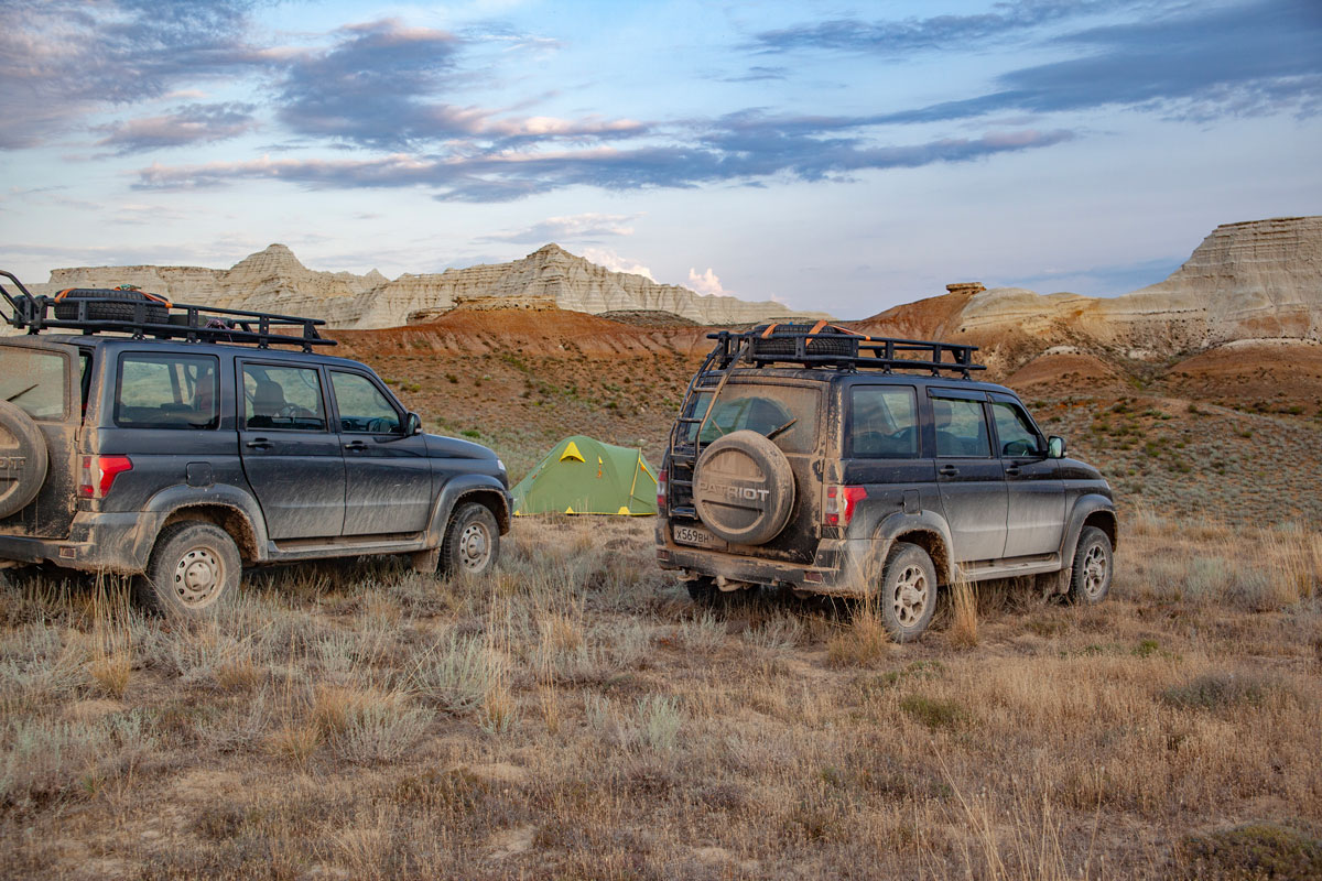
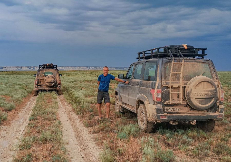
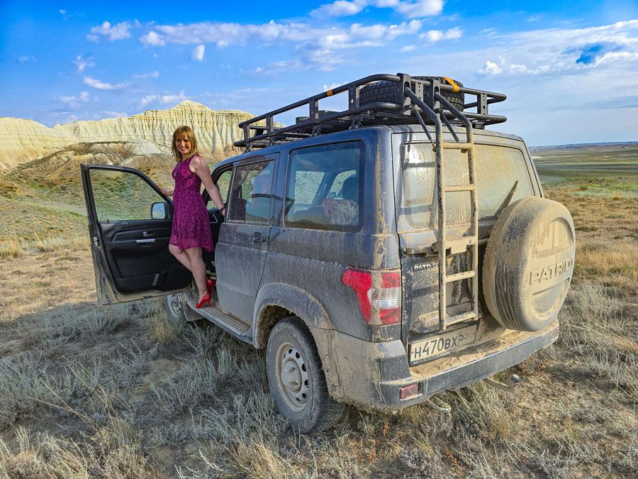
Two twins - UAZ Patriot 2025 in the "Expedition" configuration. These cars have already traveled half of Russia, all of Mongolia, Kazakhstan, the Caucasus, and together with their drivers know everything about the mountains, steppes, sandstorms, river fords, snow drifts and icy passes.
So, we set off on a journey along the Pamir Highway - the adventures begin!
Tour organizers and guides on the route:
EVGENY ANDROSOV
Professional traveler, climber, mountain guide and tour instructor with 35 years of experience. Has been to all continents, 82 countries of the world and 72 regions of Russia. Organizer of hundreds of author's tours, expeditions, hikes, ascents, creator of many new, non-standard tourist routes...More
VICTORIA SHATALOVA
Professional traveler, organizer of author's tours with 16 years of experience. Has visited 37 countries of the world and 82 regions of Russia. Organizer and participant of many hikes, rafting, car trips, ascents, including ascent to the highest and most dangerous volcano in Eurasia - Klyuchevskaya Sopka (4850 m), ski trips in the northern and polar Urals, Murmansk region and Kuznetsk Alatau... More
Itinerary day by day:
Dushanbe
We meet at the Dushanbe airport. Transfer to the hotel, walks around the city. In the evening we go to a teahouse - one of the best in the entire post-Soviet space, where we have dinner and get to know each other.
Nurek hydroelectric power station - historical complex Hulbuk - Kulyab
We check out of the hotel, get into the cars and set off on a Journey!
Today we have to drive 180 kilometers along a good asphalt road to a fairly large (4th largest in Tajikistan) and ancient (arose in the early 16th century on the site of settlements that are 2700 years old!) city of Kulyab. On the way we will stop at two very interesting places.
First we will make a small "detour" of 20 km to look at the Nurek hydroelectric power station - a symbol of the power, progress and ambitions of the USSR, the highest embankment (not concrete!!!) hydroelectric power station in the world. It is taller than the Eiffel Tower and St. Isaac's Cathedral, and this height is made of soil and rocks in a mountain gorge and is capable of withstanding earthquakes of up to 9 points!
And 30 km before Kulyab we will stop in Khulbuk - a large historical complex in Tajikistan. It includes the Palace of the Ruler, the citadel and the surviving parts of the settlement of the 9th-12th centuries. At the end of the last century, Khulbuk was included by UNESCO in the candidates for the title of World Historical and Heritage Site.
Upon arrival in Kulyab, we will check into a hotel and walk around the city until the end of the day and evening. There is also much to see here: ancient mosques and madrassas, the mausoleum of Mir Sayyid Ali Hamadoni, a Tajik figure of science and culture of the 14th century, a giant marble tombstone, the inscription on which says that Amir Muhammad bin Shaikh Abdullah, one of the ancient rulers of the state that once existed in those places, is buried here. There are many workshops and shops in the city where they produce and sell the famous Kulyab carpets and dresses, which are a desired souvenir for many guests of the city.
Childukhtaron Reserve - Valley of 40 Girls
Today we will deviate a little from the Pamir Highway and make a small circle (about 130 km) to visit the Childukhtaron Reserve - Valley of 40 Girls.
The name of the reserve comes from a legend that tells how 40 girls, defending their village from the Mongol invasion, realized the inevitability of defeat and prayed for deliverance from the torment that the invaders would inevitably bring them. Their prayers were heard and their bodies turned into stones to remain pure and innocent forever. For centuries, this place has been considered sacred by local residents. Every spring, they come to the reserve to decorate the rocks with flowers and ribbons.
The valley is surrounded by the Khazrati Shokh mountain range with hiking trails. We will also take a walk in this picturesque area, and then return to the Pamir Highway, near which we will stop for the night, setting up a tent camp.
Kulyab - Khorog
We move further along the Pamir Highway towards the city of Khorog - the administrative center of the Gorno-Badakhshan Autonomous Region of Tajikistan. The city is located at an altitude of 2200 meters above sea level and in its southeastern part borders with Afghanistan.
The road between these two cities will already be bad (although in some areas there is still asphalt, but there are many road works due to which even a complete closure of the road during the day is possible), we have to drive 400 km., so we allow 2 days for it.
Hundreds of kilometers along the cliff and steep river bank. Beautiful and dangerous if you drive fast. We will drive slowly 😀
Khorog - Garm-Chashma - Yamchun Fortress - Bibi Fatima-Zahro Hot Spring - Abrahim-Kala Fortress - Langar
From Khorog, you can go towards Kyrgyzstan along a good asphalt road recently built by the Chinese, but we are going to explore this region, and not drive through it as quickly as possible, so we will continue driving along a dirt road along the Panj River, which forms the border with Afghanistan. After 42 kilometers, we will make a long stop near the open-air swimming pool of Garm-Chashma, which means "Hot Spring" in Tajik. The pool is of natural origin, it is like a large bathtub, cemented with limestone formations, over which massive sloughs hang like a white, bizarre swelling. Visiting the hot spring is free, the water is muddy with limestone, at a comfortable temperature. Men and women bathe in turns, according to the schedule posted on the gate. The waters of the spring are healing, they help to get rid of skin and gynecological diseases, diseases of the musculoskeletal system, respiratory organs and cardiovascular system. We will not use the health treatments either.
There is a canteen next to the spring, where we will have lunch, and then move on.
After 150 kilometers we will visit one of the most iconic historical sights of the Pamir Highway - the Yamchun fortress. This beautiful fort with stone walls and towers is located at an altitude of 3000 meters above sea level and rises above the valley of the Panj River, flowing 400 meters below. In the cold and isolated from the world Wakhan Corridor 2000 years ago life was in full swing - it was one of the main routes of the Great Silk Road. The Kushan Empire that reigned here built many fortresses to protect trade from foreign raids and tax collection. The Yamchuna Fortress was one of the main structures built according to all the rules of military science and was virtually impregnable, protecting and controlling the flow of people and goods passing through the Wakhan Valley. Today, only the upper part remains, the lower cascade of walls and towers is destroyed, but what remains is impressive.
And just 2.5 kilometers from the fortress, there is another hot spring - Bibi Fatima-Zahro, named after the daughter of the Prophet Muhammad. It is located in a narrow gorge at an altitude of 3,200 meters above sea level. The water here is transparent, without the smell of hydrogen sulfide, saturated with radon and other useful substances.
We will swim in the spring, and then visit another historical landmark - the remains of the Abrashim-Kala fortress, which was built to protect a branch of the Great Silk Road from Chinese and Afghan invaders. Little remains of this fortress, but its ruins offer perhaps the most picturesque view of the entire Panj River valley.
By evening we will arrive in the village of Langar, which is located at an altitude of 3,000 meters and is considered the beginning of the Wakhan Corridor. Here the Wakhan and Pamir rivers merge, forming the Panj River - the very one along which we have been traveling for the last 5 days.
There are several options for guest accommodation in Langar, the landscapes surrounding the village are impressive. And the climate here, despite the high altitude, is quite mild and pleasant for living or, like ours, for a short stop.
Langar - Murghab
After Langar, the road goes up in a sharp serpentine, gaining 300 meters in just 4 kilometers. Ahead, before reaching the asphalt section of the Pamir Highway, is one of the most deserted sections of the route, with a constant climb.
A narrow, rocky and completely deserted road winds through the mountains and gorges, passing an oncoming car here is a big problem, fortunately there are very few of them here. The Pamir River, along which we are now driving, is very narrow in these places - it is easy to ford it. The border that runs along the river is practically unguarded, only 50 meters away from us is Afghanistan. Here you forget that you live in the 21st century - as if you were transported in a time machine 2000 years back, to the times of the Great Silk Road...
After about 150 kilometers of this road, more like a washboard among mountain gorges, we come out onto an asphalt section of the Pamir Highway. The asphalt here, however, was laid back in the days of the Soviet Union, but it is still a road, and not what it was before...
The landscapes become completely different - instead of snow-capped mountain peaks and deep gorges, a high-mountain desert with low mountains in the distance opens up to the eye. In this part of the Pamirs is the highest mountainous part of the world after Tibet, its valleys and slopes are at an altitude of 3500-4200 m above sea level.
After 130 kilometers and about 3 hours of travel, we will arrive in the village of Murghab, where we will try to settle in for the night in a guest house. The village is located at an altitude of more than 3600 meters above sea level and is the highest-altitude settlement in the territory of the former USSR, and the monument to the leader of the world proletariat erected in it is the highest-altitude monument to Lenin (not counting the bust of Lenin on the peak named after him). So the night will not be easy. Most likely, most of us will be covered with "mountain sickness" - headache and nausea are guaranteed. However, smooth acclimatization and overnight stays in the previous nights at altitudes of 2000 - 2500 meters will play a positive role and the signs of mountain sickness should not be as acute as with a sharp rise and overnight stay at such a high altitude.
Murghab - Akbaital Pass - Karakul Lake - Kyrgyz border - Sary-Tash village
A difficult day. The Kyrgyz border is 187 kilometers away, but to get there, we will have to overcome several mountain passes, including the Akbaital Pass, its height is 4655 and this is the highest point of our journey.
After the pass, Karakul Lake (translated from Turkic - "black lake") awaits us - the largest lake in Tajikistan. Well, how does it wait ... it lies in a mountain basin at an altitude of 3914 m, surrounded by desert rocky ridges for 25 million years and hides a lot of mysteries. According to one version, it was formed by the fall of a giant meteorite, according to another - as a depression between the mountains due to tectonic processes. In the waters of the lake, border guards and local shepherds allegedly occasionally observe a fish-like creature of enormous length, swimming along the shore, whipping up foam on the water, and after diving, emitting a strange low sound that can be heard within a radius of hundreds of meters.
Be that as it may, the landscapes of the lake are beautiful: transparent dark water and the snow-capped mountains surrounding it - harsh, but very, very impressive! We will stop near the lake for a photo shoot (those who wish can celebrate their swimming at an altitude of almost 4000 meters!) and go to the border, which is located on the Kyzyl-Art pass at an altitude of 4282 meters.
After the border, we will descend along a mountain serpentine, another, but already lower pass Shirt (3440 meters) and, after 45 kilometers, the village of Sary-Tash, where there is a canteen and a guest house.
Sary-Tash village - Lenin Peak base camp - Puteshestvennikov Pass
Today we could have already arrived at the finish point of our trip - the city of Osh, which is just under 200 km away along a good asphalt road, but why do we need that?
Today we will once again deviate from the Pamir Highway to see Lenin Peak - an impressive seven-thousander, a place of pilgrimage for climbers and feel like climbers ourselves a little. Just a little like climbers 😀
From Sary-Tash village we set off for the Lenin Peak base camp! Depending on the weather and road conditions, it will take 2-3 hours to drive, after which we will take a walk to the Puteshestvennikov Pass (4170 m). 5 km one way, 500 meters of elevation gain. Given our already good acclimatization, the altitude should not be a problem.
The pass offers a great view of Lenin Peak, and the views along the route are simply breathtaking, you can't miss it! However, if you don't feel up to the challenge of this trek, you can stay in the camp and have a good time there, chatting with the climbers and contemplating the surrounding peaks.
Upon our return, we set up tents and prepare a camp dinner, which we definitely deserve today!
Lenin Peak Base Camp - Osh
In the morning we say goodbye to the climbers' camp and head to Osh. It's a 5-6 hour drive, so upon arrival we'll have enough time to take a sightseeing tour of the city, fortunately there's a lot to see here, and one day tomorrow, which we'll completely dedicate to this city, is clearly not enough for all the sights.
Osh is the second most populous city in Kyrgyzstan and its important economic and cultural center. In addition, it is one of the oldest cities in Central Asia with a history of more than 3 thousand years! It would be wrong not to touch this history and culture!
Osh
In the morning we will climb Mount Suleiman-Too – the main natural attraction of Osh, its symbol and pride. The mountain is named after the prophet Solomon (Suleiman), who once prayed here. It has long been considered a sacred place, which still attracts Islamic pilgrims from all over the world. In 2009, Suleiman-Too became the first site in Kyrgyzstan to be included in the UNESCO World Heritage List.
Here, on the eastern peak of Mount Suleiman-Too, we will visit the Mausoleum of Babur Shah – one of the most ancient architectural monuments in the country. At the end of the 15th century, the ruler of the state of Moghulistan – Sultan Mahmud Khan – built a cell on the site of a stone slab where, according to an ancient legend, the prophet Suleiman prayed. Later, this cell began to be called the Takhti-Suleiman mosque, and now it is also called the house or mausoleum of Babur.
At the foot of Mount Suleiman-Too there is a yurt town - the Alymbek ethnocenter, which we will also visit. There you can see a unique building built in 1995 - a three-story yurt with beautiful interior decor, built to celebrate the 1000th anniversary of the epic "Manas". Inside the three-story yurt there is a small ethnography museum, the exhibits of which introduce visitors to the history of the region and its famous figures.
We will also visit the Suleiman-Too Cathedral Mosque, located nearby. Opened in June 2012, the mosque became the largest mosque of that time not only in the city of Osh, but in all of Central Asia. Today it is the spiritual center of traditional Islam for all believers in the south of Kyrgyzstan, as well as a beautiful building and one of the calling cards of Osh.
Afterwards we will go to the central square of the city on Kurmanjan-datki Street, which is decorated with the Cathedral of Archangel Michael - the only monument of Russian Orthodox architecture in the city of Osh. It was founded in 1909 on the site of a temporary church built in 1877.
After having lunch in one of the city's cafes, we will go out of town to see two interesting sights - the Chil-Ustun karst cave - an amazing creation of nature and a popular tourist attraction - it is located 20 km from Osh and the Aravan rock 29 km from the city, where you can see valuable historical artifacts - rock paintings and petroglyphs.
We return to Osh, farewell dinner in one of the cafes, overnight stay in a comfortable hotel.
Spare days
Spare days in case of breakdowns and repairs of cars, delays on the way due to road closures, as well as possible delays at the border of Tajikistan and Kyrgyzstan. If the spare days are not used, we will take a short trip to the "most Uzbek" city of Kyrgyzstan Uzgen or use them for a more detailed acquaintance with Osh.
To home
Transfer to Osh airport and flight home.
Tour Cost: € 2050
The tour price includes:
- 4x4 travel all days of the tour,
- hotel accommodation (4 nights), guesthouse accommodation (4-9 nights depending on availability),
- tent accommodation all other days of the tour,
- three meals a day - hot breakfasts and dinners, as well as snacks (dry rations) for lunch on days when there are no canteens or cafes on our way,
- general camping equipment (tents, burners, gas, drinking and technical water, cooking utensils, camping equipment), a generator, as well as a first aid kit, satellite communication for emergency calls,
- entrance tickets to museums and other tourist attractions specified in the tour program,
- registration of tour participants in Tajikistan, permits to the border zone, to cross the Tajik-Kyrgyz border, to national parks, entry tickets to nature reserves,
- tour organizers and drivers work 24/7,
The tour price does NOT include:
- air tickets to Dushanbe / from Osh,
- meals in canteens, cafes and restaurants,
- accommodation in the cities of the beginning/end of the tour before/after the tour dates,
- transfers from Dushanbe airport / to Osh airport before/after tour dates,
- entrance tickets to museums and other tourist attractions not listed in the tour program,
- medical insurance,
- visa support, consular fees,
- expenses of participants related to force majeure circumstances (missing a flight, due to vehicle breakdowns, border closures, etc.),
- clothing and personal equipment of participants,
- souvenirs and other personal expenses of participants,
- other expenses not specified in the «included in the price» section
The tour does not require any special skills or fitness from the participants and from this point of view is suitable for anyone. However, it is very important to be ready for early rises and long journeys (from 100 to 500 km per day), including on bad and very bad roads.
Transfers, as a rule, will take up most of the day. Participants should also be prepared for delays along the way and route adjustments due to vehicle breakdowns, flat tires and/or road closures.
Bad weather, time zone changes, lack of a normal daily routine and food can add to the discomfort of the tour.
In the mountains, we will climb and spend the night at a fairly high altitude (more than 4,000 meters), this does not pose a danger to the life and health of a healthy person, but can be accompanied by unpleasant phenomena: headache, nausea and vomiting, swelling of the face and limbs. In this regard, if you have any chronic diseases or contraindications for health reasons, you are obliged to inform us about it before signing up for the tour and making an advance payment.
Many overnight stays on the route are tent-based by default. Sometimes in populated areas we can spend the night in guest houses where they are available and there are free places, but it is worth considering that such accommodations often do not have a shower, and the toilets are outside. Overnight stays in comfortable hotels with amenities familiar to a European resident can only be expected in Dushanbe, Kulyab and Osh (4 nights out of 14).
Before signing up for this tour, you should soberly assess your capabilities and habits - the tour is an expedition and does not imply comfort, but it does imply many road adventures (tire service, car repairs, changing the route due to circumstances, the possibility of serious delays along the way and even being late for a flight home), not always pleasant for most people.
If you are used to comfort and everything going according to plan, this tour is CONTRAINDICATED for you!
Our tour is extreme in terms of temperature changes and possible weather phenomena. During the day it can be 30-35 degrees Celsius, and at night in the mountains the temperature can drop to zero degrees. Rain and fog are possible in the mountains, and strong winds are possible on high-mountain passes. Therefore, you need to take clothes for both heat and cold, rain. We recommend taking a set of light travel clothes: hiking pants, a long-sleeved jacket and a T-shirt, a baseball cap or a Panama hat, sandals or light sneakers, as well as a set of warm clothes: warm pants, a fleece jacket or sweater, a down vest or a light down jacket + a membrane jacket, a hat and gloves, trekking boots or sneakers.
Don't get carried away with revealing clothes (shorts - for both women and men, short skirts and dresses for women, open T-shirts and T-shirts with deep necklines) - the countries are Muslim and in many areas, especially those bordering Afghanistan, such clothes can be perceived by local residents as an insult to their traditions with all the ensuing consequences.
We will spend many nights in tents, which means that you will definitely need a camping mat (foam or inflatable), a sleeping bag for a temperature of comfort up to -5 degrees, a set of thermal underwear or its replacement for sleeping in cold conditions, a set of personal dishes (bowl, mug, spoon), headlamps, rubber slippers.
For walks around cities and in nature, you will need a small backpack of 20-25 liters (you can use a city one), sunglasses and sunscreen. To visit mosques, as well as walks in cities and towns bordering Afghanistan, women must have a headscarf.
Due to the abundance of dust on the road, you will need 2-3 packs of wet wipes.
1. We do not provide visa support to Tajikistan and Kyrgyzstan. If you need a visa to enter these countries, you must take care of obtaining it yourself.
2. No vaccinations are required to enter Tajikistan and Kyrgyzstan.
3. Medical insurance for those traveling abroad is mandatory. Take care of purchasing it yourself in advance from one of the trusted insurance companies.
4. In Dushanbe, you can (and should) exchange dollars/euros for Tajik somoni for personal expenses on food in cafes and restaurants, buying souvenirs, etc. Almost all large retail outlets in Tajikistan and Kyrgyzstan accept bank cards, but you should not count on paying with cards in the mountains. .
4. Please note that the border between Tajikistan and Kyrgyzstan, despite the normalization of relations between these countries in recent years, is a problematic area and if tensions arise, it may be closed for exit from Tajikistan / entry into Kyrgyzstan. In this case, the route will be adjusted and after driving part of the Pamir Highway we will return to Dushanbe. This is a force majeure circumstance for which the tour organizers cannot bear responsibility, including financial, in the event that participants purchase new return tickets.
1. If you are interested in this tour, leave a request through the registration form on this page or write to us at WhatsApp, Telegram or by email, we will contact you and answer all your questions.
2. To reserve a place, you must make an advance payment of 30% of the tour cost. The advance payment is made through the website (section Payment) and is refundable 45 days or more before the start of the tour and non-refundable, unfortunately, less than 45 days before the start, if the refund is related to your refusal to participate (for any reason). If the tour does not take place due to our fault, due to the group not being formed, or due to force majeure, the advance payment will be guaranteed to be returned to you in any case.
3. The final payment is made on the first day of the tour. You can pay using the QR code that the tour organizer will provide you, in cash, or through the website.
© The program description uses photographs by Evgeny Androsov and licensed stock photos from Shutterstock.